Brandenburg (Havel)
Medieval Urbanization between Ecclesiastical and Secular Lords
If one takes a look at the urban development of Brandenburg an der Havel, the medieval settlement picture is characterized by a versatility that can hardly be found in any other municipality in the Mark Brandenburg region. This is not least due to the interests of various actors who tried to gain a foothold in Brandenburg in connection with the medieval land development east of the Elbe. For ecclesiastical and secular lords alike, the advancement of municipal development was an important instrument of lordly penetration of the space they claimed. The medieval urban development in Brandenburg an der Havel vividly reflects the intentions, planning and measures associated with this.
The foundation of Brandenburg was by no means from wild roots. Rather, the urban development was based on Slavic settlement structures, at the top of which was the later so-called Pribislav Castle, named after the last Slavic prince to reign here, which had its place on today’s Dominsel (Cathedral Island). When Pribislav died in 1150, he had already found his final resting place in a Christian chapel connected with the castle.
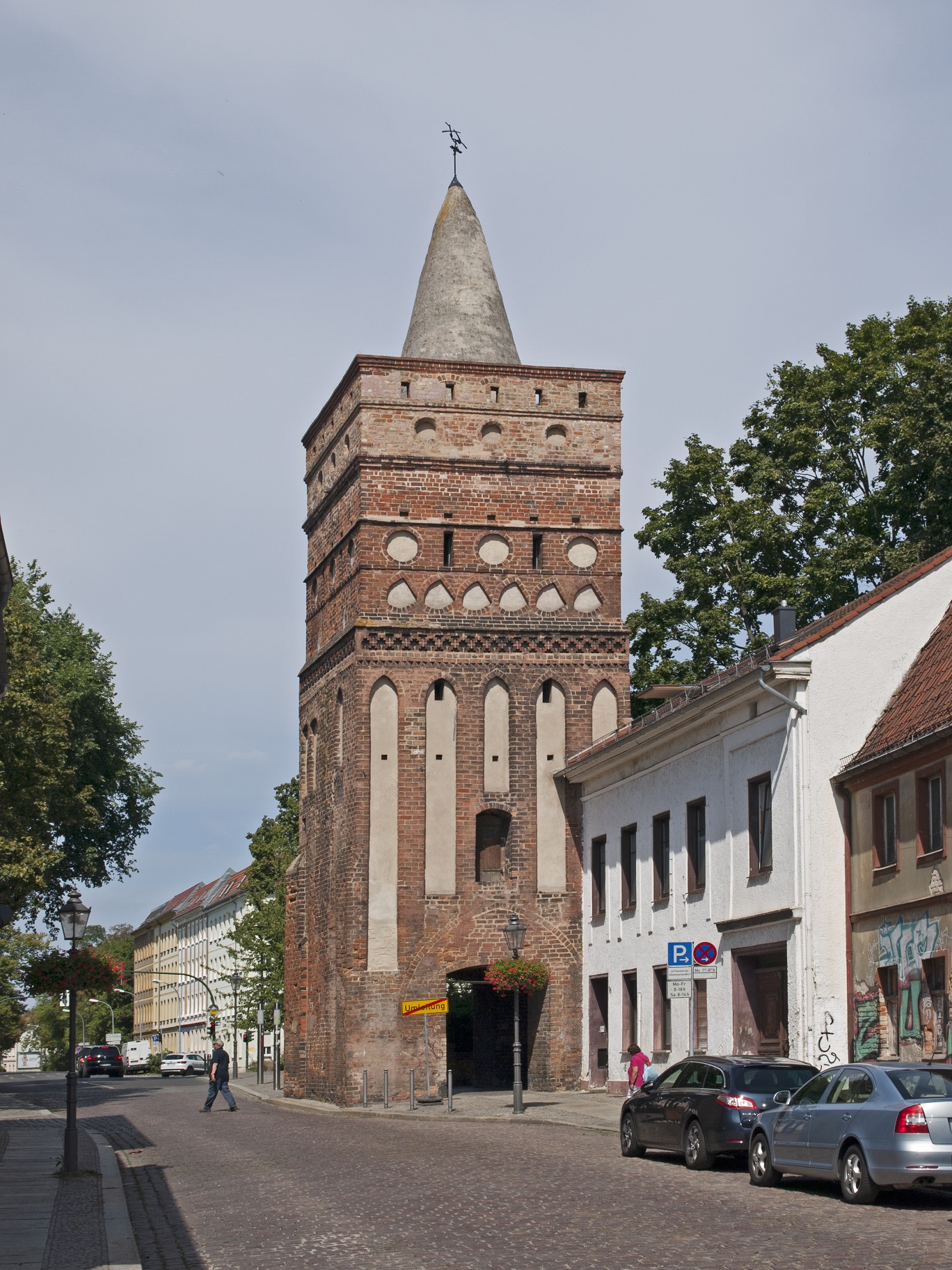
Fig. 1: The Rathenow Gate Tower, completed around 1320, is one of the medieval fortifications of Brandenburg’s old town.
Now the burgraves expressed their claims more and more offensively, intending to exercise lordly power over the Dominsel and beyond in the name of their lord – the Roman-German king. However, with the Ascanians, who from 1157 onwards rose to become margraves of Brandenburg, they encountered powerful competitors who pursued their own lordly ambitions in the vicinity of the Dominsel. In fact, older Slavic rights extended beyond the local castle, since four settlements were connected with the seat of power, which persisted through the Slavic period and around which the settlement pattern gradually changed. These are the small and large Domkietz (Cathedral Neighborhood) on the Dominsel, the altstädtischer (Old Town) or Wendkietz in the area of the Altstadt (Old Town) Brandenburg and the neustädtischer (New Town) Kietz in front of the Neustadt (New Town) on the Mühlendamm (Mill Dam). These designations trace back to settlement structures that developed with the influx of newcomers from the region of the Elbe and Saale rivers in the 12th century. The earliest settlement of the immigrants was Parduin (pronounced pardūn), which was established on royal territory around 1160 and later developed into the Altstadt of Brandenburg. The first traces of this settlement are documented in the surroundings of the church of St. Gotthard, where a group of Premonstratensians from Leitzkau had already settled around 1147.
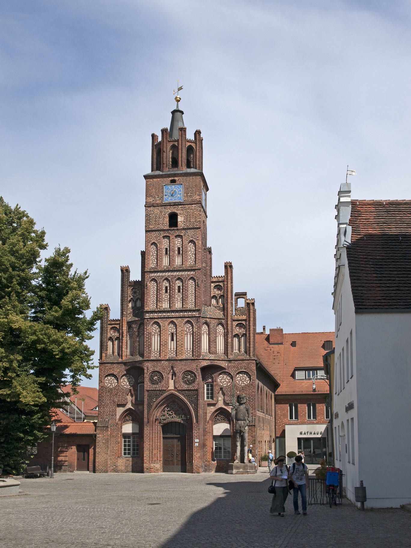
Fig. 2: Town Hall of Brandenburg’s Old Town, with the 15th-century Roland statue in front of the building. The statue was moved here from Brandenburg’s New Town in 1946.
The reform-oriented monks were intensively engaged in Christian missionary work and pastoral care, far beyond Parduin. Especially the new settlers working as merchants moved to their vicinity, and St. Gotthard served them as a parish church. Soon the Bishop of Brandenburg, Wilmar, appointed the convent of the Premonstratensians to cathedral chapter. Their relocation to the Dominsel followed in 1161. Four years later, the construction of the cathedral began, which was to replace an older cathedral church located near the castle. St. Gotthard developed into the parish church of the settlement Parduin. Its name comes from an old branch of the Havel of the same name, which can be translated into Dutch as “strong mooring rope”, and refers to the important role of water in the local urban development. The Havel, namely, marked the lordly border between the royal territory belonging to Havelland, on which the settlement of Parduin was located, and the Zauche, which belonged to the Ascanian estate. Around 1170, a new settlement was established here on the other bank of the Havel on parts of the Stutzdorf/Deutschendorf district, which was first mentioned in documents under the name Neustadt Brandenburg in 1197. This first municipality, founded east of the Elbe by the margraves of Brandenburg, began to outstrip the Altstadt, as it was called from then on, in economic terms through targeted promotion. This was achieved not least with the help of a systematic expansion of urban infrastructure, which can still be seen today in the town’s layout. As in other municipalities in the Mark Brandenburg, a Mühlendamm was raised during the first half of the 13th century, which connected the Neustadt with the Dominsel. This structure dammed the Havel River to be able to drive water mills. In addition, the Mühlendamm was an important transport route that bridged several Havel islands and reached solid land at Krakau, a district that is now incorporated into the town. A large part of the land transport between Magdeburg and Berlin (Spandau) or further in the direction of Posen and Silesia, which was directed to the Neustadt of Brandenburg with the help of the Mühlendamm, passed through here. The medieval layout of the town is characterized by a conspicuous crossroads, which converged from four directions directly at the Neustadt market. Thus, the main street offered a connection to the Altstadt in extension over the Lange Brücke (today’s Jahrtausendbrücke, Millennium Bridge), which probably dates back to the 10th century, and from there on to Rathenow.
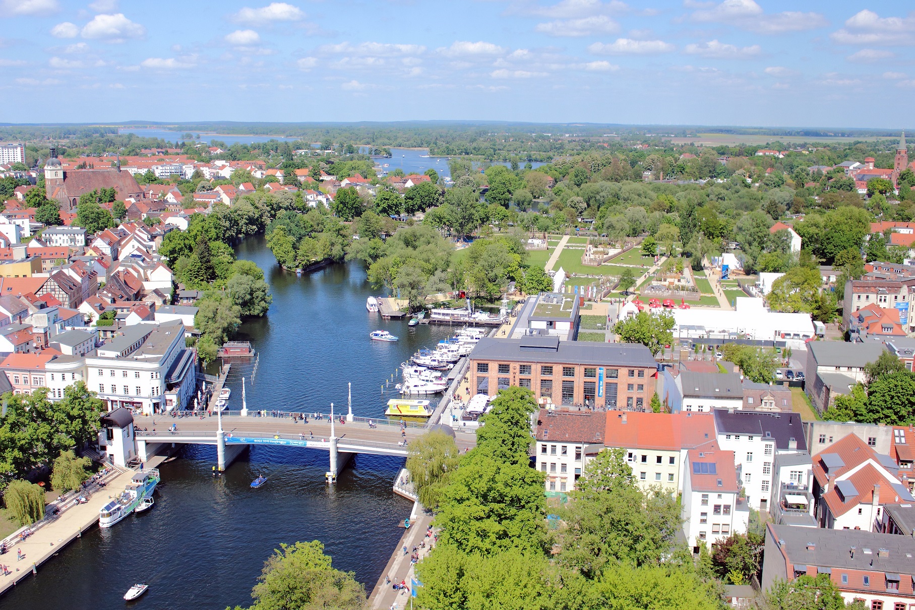
Fig. 3: Brandenburg an der Havel with the Millennium Bridge, an important landmark of the city. Inaugurated in 1929 to commemorate the city’s millennium, it stands on the site of the Lange Brücke, a bridge whose history dates back to the Middle Ages (photo: 2015).
The Sankt-Annen-Strasse, for its part, conveyed traffic into the Zauche, while the Steinstrasse received the country road leading from the Elbe and Magdeburg. The layout of the Neustadt clearly shows the pattern of a town laid out according to plan in the Middle Ages, with a concentration on trade and commerce. The citizens of Neustadt had their own parish church, St. Catherine. From 1286, St. Paul’s Church was built on the site of a margravial farm, which belonged to the monastery of the Dominicans who had moved to the town shortly before. Not least, the existence of this mendicant order marked the economic success of the Neustadt, whereupon the town foundation planned by the Archbishop of Magdeburg in Wusterwitz stagnated. The development of the Altstadt of Brandenburg was also outstripped by the Neustadt. Only when it was able to eliminate the influence of the competing burgraves in the 1240s did the Brandenburg margraves begin to specifically promote the Altstadt by allowing a planned expansion of the Altstadt area. This was followed in 1249 by a transfer of the villages of Luckenberg, Blosendorf and Kallenberg to the Altstadt, with the population living there being declared citizens of the town. During the expansion of the town, the settlement house of the Franciscans, who had been living there since 1234, and their St. John’s Church, which was under construction, were also integrated into the Altstadt. The incorporation of Brielow and Wendkietz followed in 1290 and 1308, respectively. With the support of the Ascanians, the Altstadt, with its parish land, had extended itself as far as Lake Quenz. The Neustadt, which initially did not have a parish land, was also able to extend its influence to the surrounding area and take possession of the villages of Planow, Stenow, Kietz Woltitz, Krug Krakow, Gröben, Schmölln, Wendgräben and Duster-Reckahne.
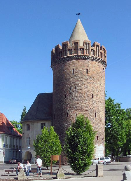
Fig. 4: The Steintor Tower in Brandenburg’s New Town, built in the first half of the 15th century.
The fortification of both towns, which began in the first half of the 14th century, with its buildings that still characterize the townscape today, such as the Steintorturm (Stone Gate Tower) and the Mühlentorturm (Mill Gate Tower) in the Neustadt and the Rathenower Torturm and Plauer Torturm in the Altstadt, visibly marked for every medieval contemporary the narrower boundaries of municipal law, which was exercised in Brandenburg according to the Magdeburg model. Even more, they illustrated the defensive character of both town councils, which had separately meeting town councils and town halls built on the respective market squares. For shared interests, however, a common town hall existed, similar to that in the twin city of Berlin-Cölln, which was first mentioned in 1360 and stood on the Lange Brücke. The Neustadt, however, remained the more important of the two municipalities. This can be seen not least in the fact that under Margrave Johann it was appointed the highest thing town in his dominions in questions of interpretation of the town law. In the course of the 14th century, this resulted in a claim to validity for the entire Brandenburg Margraviate, which was intended to prevent Magdeburg’s aldermen from giving information and passing judgment.
The aforementioned water mills between the Altstadt and Neustadt Brandenburg were indispensable for the trade of both towns. Ultimately, shipping on the Havel also had a lasting impact on Brandenburg’s urban development. Already with the construction of the Mühlendamm, the building of a flood channel began, which directed the shipping traffic in a generous curve around the Neustadt. Here, customs duty had to be paid, a procedure that can be found in the documents with the paraphrase “etwas zu verrönnen” (“something to channel through”). The shipping route, which still exists today with the Jakobsgraben (Jacob’s Ditch), only gradually lost its importance in the middle of the 16th century with a new expansion of the Havel and the construction of the Kammerschleuse (Town Lock). The developments of the medieval city of Brandenburg, which are only mentioned here in broad outline, can still be found today during attentive walks through the historic town center.
The article is a slightly revised version of the essay by Sascha Bütow, Urbanisierung zwischen geistlichen und weltlichen Herren – zur Entwicklung der Stadt Brandenburg an der Havel im Mittelalter, in Die Mark Brandenburg, no. 111 (2018), pp. 10–15.
Author: Sascha Bütow
Citation:
Sascha Bütow, Brandenburg an der Havel. Medieval Urbanization between Ecclesiastical and Secular Lords, 21.09.2020, https://magdeburg-law.com/historic-city/brandenburg-havel/
Further Reading:
Harald Bodenschatz and Carsten Seifert, Stadtbaukunst in Brandenburg an der Havel. Vom Mittelalter bis zur Gegenwart, Berlin 1992.
Friedrich Ebel, Brandenburg und das Magdeburger Recht, in Beiträge zur Entstehung und Entwicklung der Stadt Brandenburg im Mittelalter, edited by Winfried Schich, Berlin 1993, pp. 157–174.
Joachim Müller, Brandenburg an der Havel. Von der Frühstadt zur Planstadt, in Lübecker Kolloquium zur Stadtarchäologie im Hanseraum, vol. X, Vorbesiedlung, Gründung und Entwicklung, edited by Manfred Gläser, Lübeck 2016, pp. 321–338.
Joachim Müller, Brandenburg an der Havel. Altstadt und Neustadt, in Führer zu archäologischen Denkmälern, vol. 37, Potsdam, Brandenburg und das Havelland, Stuttgart 2000, pp. 230–237.
Winfried Schich, Die Bedeutung von Brandenburg an der Havel für die mittelalterliche Mark Brandenburg, in Wie die Mark entstand. 850 Jahre Mark Brandenburg, Fachtagung vom 20. bis 22. Juni 2007 in Brandenburg an der Havel, edited by Joachim Müller, Klaus Neitmann and Franz Schopper, Wünsdorf 2009, pp. 431–451.
Images:
Figs. 1–4: Wikimedia Commons, CC BY-SA 4.0 (Fig. 4: Lienhard Schulz).
Gartz (Oder)
Luckau
Perleberg
Burg
Görlitz
Magdeburg
From market rights to a widespread municipal law:
The city of Magdeburg, famed well into the early modern period as the birthplace of the influential Magdeburg law whose reach extended deep into the eastern part of Europe, first finds mention in written sources in the year 805 CE, in the Capitulare of Diedenhofen (Thionville) issued by Charlemagne, who ruled from 768 to 814. Named as ‘magadoburg’, it was to serve as one of a number of checkpoints to be established along the rivers Elbe and Saale for the purpose of suppressing the trade in arms to the Slavic regions.
More than a century passed hereafter before Magdeburg next appeared in sources preserved for posterity; King Otto I (reigned 936–973) founded a Benedictine monastery there, dedicated to Saints Innocent, Peter and Maurice, on 21 September 937, and endowed it richly in the years that followed. As the medieval empire had no capital, the German Holy Roman Emperor effectively exercised a peripatetic dominion, constantly riding through its regions. Magdeburg, located at a ford across the midstream Elbe and therefore at an interface to the Slavic world, became Otto’s preferred base.
Written sources record the presence of a ‘palatium’ belonging to Otto in Magdeburg; the term signifies one or more representational buildings in which he conducted the affairs of his office – initially as king, from 962 onward as Holy Roman Emperor -, received deputations, issued privileges and pronounced judgement. This is indicative of architectural development at an early stage in Magdeburg’s existence. In the year 968, Otto succeeded in having the Pope elevate Magdeburg to an archbishopric, whose inaugural archbishop, Adalbert of Magdeburg (in office 968-981), ruled over the newly established suffragan bishoprics of Merseburg, Meissen and Zeitz, alongside those of Havelberg and Brandenburg. Among the areas covered by the new archdiocese were vast territories east of the Elbe, in many of which Christianity was yet to gain any foothold. Magdeburg was now of nominally equal rank to Trier, Mainz, Cologne, Salzburg and Hamburg-Bremen, the Empire’s traditional archdioceses.
Hard on the heels of this meteoric rise came a long-drawn-out period of decline for Magdeburg, when, in the summer of 983, a Slavic rebellion reversed a great deal of the region’s achievements east of the Elbe; the bishoprics in Brandenburg and Havelberg were lost, as was dominion over the associated territories, which saw the young archdiocese suffer a painful contraction. The years that followed loosened Magdeburg’s royal association, and the late Ottonian period inflicted a further loss of eastern influence on Magdeburg in the shape of the establishment under Otto III (reigned 983-1002) of the Archdiocese of Gniezno. The conflictual policies towards Poland pursued by the subsequent Holy Roman Emperor Henry II (reigned 1002-1024) led to Merseburg replacing Magdeburg as the preferred royal base in eastern Saxony. The ascendancy of the Salian dynasty only made matters worse for Magdeburg, which now saw Goslar attain the position of Saxony’s premier city under the emperors Conrad II (reigned 1024–1039) and Henry III (reigned 1039–1056).
Beginning in the eleventh century’s second half, conflict between the emperors Henry IV (reigned 1056–1105) and V (reigned 1105–1125) and Saxony’s nobility strained royal relations with Magdeburg’s archbishops. The area around the Ore Mountains was frequently the site of the ensuing hostilities, with the effect that Magdeburg was often ‘close by’ the king, yet simultaneously, due to the involvement of the city and its archbishops in the troubles, distinctly removed from him. The consequence was further loss of influence, territory and favour for the church in Magdeburg. A brief rapprochement took place in the reign (1125–1137) of Lothar III, who arranged for the appointment of Norbert of Xanten as the city’s archbishop (an office he held from 1126 to 1134); yet Magdeburg’s difficulties resurfaced under Conrad III of the Hohenstaufen dynasty (reigned 1138–1152) because the city had taken the side of the rival house of Welf. It was not until Wichmann of Seeburg, who had been transferred from Naumburg to Magdeburg at the instigation of Frederick Barbarossa (reigned 1152–1190), took the archbishop’s throne (1152/54-1192) that the conflicts abated and Magdeburg began to rise to renewed glory.
Magdeburg’s development from the eleventh century onward thus appears in a contradictory duality of ecclesiastical and imperial political decline and internal, architectural and urban progress. As early as the end of the tenth century, Magdeburg had acquired a mercantile settlement holding market rights, reaping the benefits of its favourable location on the eastern edge of the highly fertile Magdeburger Boerde plain on the banks of the Elbe, itself a key north-south transport route which brought the city lucrative trade from river shipping. Otto I had endowed St Maurice’s monastery in the city with the revenues from tolls and minting in the years 937 and 942, reconfirming its right to the income from this mercatus in 965 and thereby transferring to it his dominion over the market and its residents. These rights passed to the archbishop in 968, making him lord of the city; he additionally received the Königsbann (royal rights) over Magdeburg and the right of jurisdiction over the city’s Jews – in the first mention of this group in written sources – and the remaining resident merchants. Otto II confirmed and extended these endowments in the years 973, 975 and 979, additionally granting the merchants resident in Magdeburg relief from all civic dues and road, bridge and river tolls. The chronicles of Bishop Thietmar of Merseburg (in office 1009–1018) record for the year 1016 optimi civitatis, that is, the existence of a privileged stratum within the city. Conrad II, renewing privileges of the city in 1025, emphasised that Magdeburg’s citizenry had permission to conduct trade in the Holy Roman Empire and in the barbaricis regionibus (barbarian regions)[1], a concession which exerted enduring uplift on Magdeburg’s civic and economic development. The sources of this period provide outlines of Magdeburg’s further urban and legal advancement, noting the existence in the eleventh century of the office of a monastic reeve who, in the context of the archbishop’s authority over the city, exercised jurisdiction in higher criminal matters, including capital cases, and held military command.
Sources mention the existence in Magdeburg in the year 1100 of a lower reeve of the civic court, later to become the sheriff (Schultheiß). It is at this time that we find the first written records relating to the citizenry, the cives urbis, who later served alongside the sheriff as lay judges known as Schöffen (‘Schöppen’). By this time at the latest, Magdeburg had an urban municipality with its own jurisdiction over lower matters, albeit dependent on the archbishop as possessor of supreme authority over the city. Sources bear witness to guilds for specific trades (tanners and shoemakers, tailors, ornamental painters known as Schilderer) in the twelfth century’s second half, indicating the emergence of an increasingly diverse range of trades and crafts in Magdeburg. In the first half of the thirteenth century, a city Council came into being which came to run the city’s internal affairs, liaising – on occasion conflictually – with the archbishops, who had retained nominal authority. Magdeburg had joined the Hanseatic League and the league of cities in Saxony towards the end of the thirteenth century. The city’s various attempts to attain the status of a Free Imperial City failed, despite the successive slackening of its ties to the archbishopric and the eventual departure, in the early sixteenth century, of the archbishop’s seat to the Moritzburg in the city of Halle.
Magdeburg’s rise from the twelfth century onward drew on the dual influence of the city’s trade with distant regions and the development of its law. In this period, social conditions had undergone a transformation from those dominant in the tenth century, in the wake of the grand process of change, sparked by climatic, political and social shifts, that had commenced in Europe in the eleventh century’s second half and encompassed numerous facets of contemporary life. Responding to these transformations and to local exigencies, Archbishop Wichmann presided over a series of improvements in the legal rights of Magdeburg’s merchants and citizens in order to bolster their position. A charter issued by him in 1188 bears witness to some of these reforms. It abolished the principle by which a formal error in a case before court automatically led to its being thrown out. Further, it released fathers from liability for unlawful acts committed by their sons, replacing the principle of guilt by association that had been in force until that point with the modern precept, valid to this day, of the individual criminal responsibility of each person. The charter also annulled the statute of limitations for serious crimes. Finally, and not least among these reforms, it restricted legal possibilities for unduly protracting court proceedings. The applicability of these favourable provisions to both locals and those from outside the city is testament to Wichmann’s visionary foresight in that it boosted Magdeburg’s appeal as a mercantile city. This ‘Magdeburg law’ or ‘Magdeburg rights’, as it was soon called, was very much a mercantile legal code, yet it subsequently developed into a new civic and municipal law, supplemented by provisions protecting assemblies of citizens and enabling these to take their place as instruments of civic political and legal decision-making.
Magdeburg law served as a model for numerous other towns and cities, particularly in the east of Central Europe, where many localities equated it with ‘German’ law per se. Magdeburg remained in contact with some of the municipalities endowed with its law – which totalled around one thousand – for a period of centuries. Where disputes arose around a case, it was common to turn to Magdeburg and ask for a legal opinion; this practice was known, roughly translated, as ‘taking the law to Magdeburg’ or, more literally, a ‘legal procession to Magdeburg’ (‘Rechtszug nach Magdeburg’). Magdeburg’s lay judges’ bench, as its law’s ‘upper court’ (Oberhof), thus retained interpretive authority and in this way an emphatic influence over the law’s evolution which endured for centuries.
The period following these developments brought Magdeburg a golden age which radiated across a wide region. Its urban area increased notably, numerous ecclesiastical and religious institutions came into being, and the city received its famous topography of sacred buildings. These included its cathedral, the first in medieval German lands to take Gothic forms, built from 1209 onward; the monastery of Our Lady, erected in the twelfth century; the market and Council church of St John; the parish church of St Peter; and further monasteries, including those of the Franciscans and Dominicans. The well-known statue of the ‘Magdeburg Rider’ joined the ensemble in 1240. By the late Middle Ages, a small settlement had blossomed into one of the contemporary German regions’ major cities.
By Stephan Freund
Note:
[1] Diploma issued by Conrad II, no. 18, of 4 February 1025, in Die Urkunden Konrads II. mit Nachträgen zu den Urkunden Heinrichs II., ed. Harry Breslau, with contributions from Hans Wibel and Alfred Hessel, Hanover/Leipzig 1909, p. 21.
Sources
Die Urkunden Konrads II. mit Nachtragen zu den Urkunden Heinrichs II., ed. Harry Breslau, with contributions from Hans Wibel and Alfred Hessel, Hanover/Leipzig 1909.
Further reading:
Matthias Becher, Die Auseinandersetzung Heinrichs IV. mit den Sachsen. Freiheitskampf oder Adelsrevolte?, in Vom Umbruch zur Erneuerung. Das 11. und beginnende 12. Jahrhundert. Positionen der Forschung, ed. Jörg Jarnut and Matthias Wemhoff (= Mittelalter Studien des Instituts zur Interdisziplinären Erforschung des Mittelalters und seines Nachwirkens 13), Munich 2006, pp. 357–368.
Helmut Beumann, Theutonum nova metropolis. Studien zur Geschichte des Erzbistums Magdeburg in ottonischer Zeit (= Quellen und Forschungen zur Geschichte Sachsen-Anhalts 1), Cologne/Weimar/Vienna 2000.
Caspar Ehlers, Vom karolingischen Grenzposten zum Zentralort des Ottonenreiches. Neuere Forschungen zu den frühmittelalterlichen Anfängen Magdeburgs (= Magdeburger Museumshefte 24), Magdeburg 2012.
Stephan Freund, Die Gesta archiepiscoporum Magdeburgensium, in Literatur in der Stadt. Magdeburg in Mittelalter und Früher Neuzeit (= supplements to Euphorion 70), ed. Michael Schilling, Heidelberg 2012, 11–32.
Brigitta Kunz, Siedlungsentwicklung im Umfeld des Domes. Magdeburg im 8. – 14. Jahrhundert (= Veröffentlichungen des Landesamtes für Denkmalpflege und Archäologie Sachsen-Anhalt. Landesmuseum für Vorgeschichte 71), Halle an der Saale 2017.
Matthias Puhle (ed.), Otto der Große, Magdeburg und Europa, 2 vols., Magdeburg 2001.
Matthias Puhle (ed.), Aufbruch in die Gotik. Der Magdeburger Dom und die späte Stauferzeit, vol. 1 (Essays), Mainz 2009.
Matthias Puhle, Magdeburg. Kleine Stadtgeschichte, Regensburg 2018.
Matthias Puhle and Peter Petsch (eds), Magdeburg. Die Geschichte der Stadt 805–2005, Dössel 2005.
Cite as:
Stephan Freund, Magdeburg. From market rights to a widespread municipal law, in Magdeburg Law. A building block of modernen Europe, 17/11/2020, https://magdeburg-law.com/historic-city/magdeburg/
A version of the original German text previously appeared in Gabriele Köster and Christina Link (eds), Faszination Stadt. Die Urbanisierung Europas im Mittelalter und das Magdeburger Recht (catalogue of the eponymous exhibition, 1 September 2019 – 2 February 2020), Dresden 2019, pp. 190–194.
Pirna
Aken
A planned market town of Magdeburg character:
The town of Aken, located on the Elbe River, is certainly not one of the best-known legal towns of Magdeburg character, but it is nevertheless a relatively early example of the resulting typical developments within the urban constitution, which will be traced in the following.
Aken’s urban development is closely connected with the former and nearby Slavic castle Glewerp, which was used by the Ascanians, who were prosperous in the Harz region, to secure newly developed territories since the 12th century.[1] From here, they also monitored an important crossing of the Elbe. In 1212, the castle fell into the hands of a grandson of Albrecht the Bear (ruled 1123-1170), who was also called Albrecht (ruled 1212-1261) and belonged to the Wittenberg branch of the family. Presumably, this prince founded the town of Aken in continuation of an older Slavic settlement and expanded it in a targeted manner. Thus, the town is still characterized by a systematic ground plan, the exit of which was once marked by a road junction formed near the market and the town hall. The road running parallel to the Elbe between Dessau and Magdeburg met here with the road coming from Köthen and leading further to Zerbst across the Elbe. From this, the medieval town planners branched off several crossroads at regular intervals to the left and right, resulting in a square pattern (fig. 1).
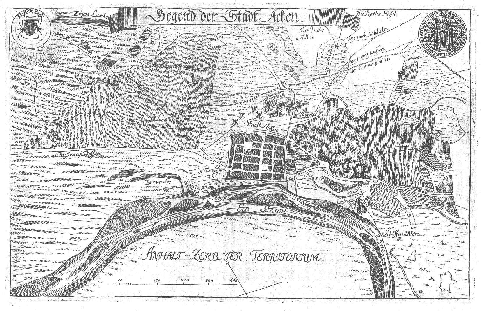
Fig. 1: Aken and its surroundings, 1720/21, source: Johann Heinrich Haevecker, Chronica und Beschreibung der Staedte Calbe, Aken und Wantzleben
It was not until the sons of Albrecht that a merchant’s house was recorded in documents in Aken in 1265, which also served as the town hall.[2] One year later, the marketplace is mentioned. In addition, there is evidence of a Schultheiß (town mayor) and of Schöffen (aldermen) for the first time in 1266. Information about their activities within the still young municipal community is provided by a Schöffenbuch (Book of Aldermen) of the town of Aken, fragments of which are still preserved today, the records of which go back to the year 1265 and are thus among the earliest among such sources from the area of distribution of Magdeburg law.[3] This work is one of the few surviving medieval sources on the town’s history, as the complete council archives fell victim to a town fire in 1485. The Book of Aldermen vividly illustrates the organization of the city’s government along the lines of Magdeburg law, in that it also attests to a college of aldermen in addition to the council. Various scribes worked on the Book of Aldermen, as can be discerned from the manuscripts documented there, which originate from different persons. The records mainly report on hereditary regulations, on the basis of which one can see, as is usual for Magdeburg law, that women could also inherit property, income and other rights. The Book of Aldermen also registers the names of important persons and officials of the city. For example, it mentions the names of the first aldermen, Bruno (1268), Heideke (1273) and Heinrich (1295), who were thus undoubtedly at the top of the municipal community. In 1271, the term town (civitas)[4] is mentioned for the first time in relation to Aken. The existence of aldermen is finally documented for the first time in 1288, although they may have already existed before. Thus, in the course of the 13th century, a typical civic community was established in Aken, which was oriented toward the customs of Magdeburg law.
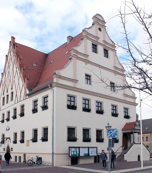
Fig. 2: Aken Town Hall, built following a town fire in 1485; it was also used as a market hall in the Middle Ages (photo: Sascha Bütow)
Between the 13th and 14th centuries, the Saxon dukes fostered the prosperity of the town of Aken. A proven means to this end was the Stapelzwang (compulsory staple), which required passing merchants to lay down their goods in Aken and offer them for sale to the local inhabitants. This regulation was valid for the land as well as for the waterway. It is unclear when Aken received this right. However, comparisons with other towns suggest that this could have happened as early as the 13th century. During this time, the Elbe played an important role as a Hanseatic arterial road. In particular, grain was transported on it in the direction of Hamburg. In addition, various goods, especially from Bohemia, such as sand, stones and wood were shipped, which were brought to Magdeburg via Aken.[5]
Not least because of this, a lively market life developed in Aken itself, in which various trades participated. Butchers owned sales stalls, the so-called Scharren, which stood directly by Marienkirche (St. Mary’s Church). In addition, there were shoemakers who owned a shoe hall first documented in 1268. Clothiers and tailors presumably presented their wares in the town hall, where there must have been specially equipped sales rooms. The cloth produced in Aken also enjoyed widespread use beyond the city limits. Thus, based on a statute from 1321, it is known that tailors from Zerbst processed further cloth made in Aken.[6] In order to be allowed to trade in Aken, customs had to be paid, which is documented here as early as 1230. This toll belonged to the dukes of Saxony and provided them with significant revenues. With the trade relations established in Aken, the town became part of the European traffic route network, as illustrated by the famous road map made in Nuremberg by Erhard Etzlaub (around 1460-1532) from 1501. Many long-distance traders must have known the place, as they could use it to bypass other customs points, such as Magdeburg or Wittenberg, thanks to the ferry that existed here.
Supervision of the market and control over the use of correct weights and measures was incumbent on the Aken town council, as was the organization of all inner-city life. The aim associated with this was primarily to ensure peace and the common good within the town. Based on this aspiration, Aken’s councilors formulated various legal principles that affected communal coexistence and were first summarized in the form of a Willkür (arbitrary code) around 1520.[7] As an impressive example of the council’s actions, this source contains not only a series of commands and prohibitions but also details of the punishments that were threatened if they were not observed. However, the archbishop of Magdeburg, as Aken’s city lord, reserved the right to confirm the regulations issued by the council.
The Aken citizenry was able to achieve considerable wealth in the late Middle Ages, which can be observed right down to individual persons. In 1392, for example, Claus Strynne, a native of Aken, acquired a share of the rights to a nearby wood district called Goldberg with fishing and meadow rights.[8] The citizens donated a not insignificant part of the fortune earned in this way to the churches of Aken in order to promote their own salvation. This primarily concerned St. Marienkirche (Church of St. Mary), to which e.g. church utensils, interest or entire plots of land were donated. The same applied to the Maria-Magdalena-Kirche (Church of St. Mary Magdalene), which was located on the territory of the older Slavic settlement and had to be demolished in 1542 due to flood damage.
Further south in the town, the citizens of Aken erected another parish church, which was first mentioned in 1265 and dedicated to St. Nicholas. Duke Johann I of Saxony (r. 1268-1285), however, converted this place of worship into a monastery in 1270, into which six canons moved.[9] Their task was to hold church services, commemorate the dead and lead an exemplary Christian life. The canons had ten houses in which they and their guests lived. The area was disrespectfully called “Pfaffenhof” (“parsons’ yard”) by the citizens of Aken, because the canons were often criticized because of their special rights. The Nicholas Monastery, for example, did not have to bear any of the city’s burdens, whereupon protests were voiced time and again. In 1288, the territorial sovereign mediated a compromise in which the canons agreed to contribute two pounds of groschen (pennies) for the appointment of the city guards and to pay ten silver marks for the construction of the Köthen Gate.[10] With this attitude directed against the monastery, the Aken councilors were conforming to a typical way of thinking within medieval city politics. According to this, in many places, the endeavor prevailed to have ecclesiastical communities participate in municipal expenditures and thus put the common good above any immunities and special ecclesiastical rights. However, this view should not be equated with a lack of piety among Aken’s citizenry. The opposite can be observed in late medieval Aken.
Traces of the medieval development have been preserved in the historic town center until today, although it was the 14th century that brought about tangible changes. During this period, the Aken council ordered new town defense constructions, which replaced wooden palisades with a stone wall first mentioned in 1335. Before that, gates and towers were built, of which the Burgtor (Castle Gate) Tower, the Dessau Tower and the already mentioned Köthen Tower have been preserved until today. These urban fortifications were strongly connected with the conflict between the Dukes of Saxony and the Archbishops of Magdeburg. Both parties claimed the possession of Aken and waged warlike conflicts around the town, in which the Gloworp castle was destroyed.[11] It was not until 1392 that a new, more castle-like structure was built by Archbishop Albrecht of Magdeburg (ruled 1383-1403). The coat of arms of Aken also changed with the Magdeburg city ruler. The head, which had already been used since the Middle Ages, was increasingly attributed to St. Mauritius, and likewise, a bishop’s figure was given a place in the center of the coat of arms, as it is still used today.
Author: Sascha Bütow
Citation:
Sascha Bütow, Aken. A planned market town of Magdeburg character, 18.06.2020, https://magdeburg-law.com/historic-city/aken/
Footnotes:
[1] On the Ascanian expansion in the area around Aken and beyond, cf. Partenheimer, Lutz, Albrecht der Bär. Gründer der Mark Brandenburg und des Fürstentums Anhalt. 2nd edition Cologne, Weimar, Vienna 2003, pp. 30 and 38.
[2] Neubauer, Ernst, Die Schöffenbücher der Stadt Aken. In Geschichtsblätter für Stadt und Land Magdeburg 30 (1895), pp. 251–328, here p. 253, no. 17.
[3] Magdeburg, Landesarchiv Sachsen-Anhalt (State Archive Saxony-Anhalt), cop., no. 405a.
[4] Schwieneköper, Berent, Aken, in, Handbuch der historischen Stätten, vol. 11: Provinz Sachsen-Anhalt, edited by Berent Schwineköper. 2nd edition Stuttgart 1987, pp. 2–4, here p. 3.
[5] Pelec, Ortwin, Die Elbe. Handelsweg vom 13. bis 17. Jahrhundert, in Alles im Fluss. Menschen, Waren, Häfen auf den Wasserwegen vom Rhein bis zur Weichsel, edited by Rudolf Holbach and Stephan Selzer, Wismar 2020, pp. 105-124, here p. 110.
[6] Referred to as “Akens want” (Aken Garment). See Codex Diplomaticus Anhaltinus. Vol. 3: 1301–1350, edited by Otto v. Heinemann, Dessau 1877, pp. 268-270, no. 409, here p. 269.
[7] Zahn, Wilhelm, Willkür der Stadt Aken, in Geschichtsblätter für Stadt und Land Magdeburg 18 (1883), pp. 196–199.
[8] Hertel, Gustav (ed.), Urkundenbuch der Stadt Magdeburg, vol. 1: until 1403. Halle (Saale) 1892, p. 438, no. 709.
[9] Zahn, Wilhelm, Die Stiftskirche St. Nicolai in Aken an der Elbe, in Geschichts-Blätter für Stadt und Land Magdeburg 19 (1884), pp. 47–79, 141–162, 266–293.
[10] Pfeffer, Friedrich Gottfried Carl, Chronik der Stadt Aken an der Elbe, Zerbst 1821, pp. 20-21.
[11] Georges, Otto, Geschichte der Stadt Aken an der Elbe, Köthen 1908, pp. 13-14.